
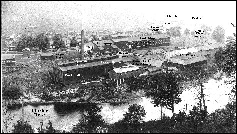
The ghost town site of Arroyo is located in the Allegheny National Forest on the National Wild and Scenic Clarion River and is an excellent example of a 19th to early 20th century lumber and tannery community. The site has been occupied in some fashion since the early 1830's and the remnants of the tannery complex provide an excellent visual representation of one of the major past industries of Elk County.
The tannery was operational until 1925 and the significance of the site has been noted by the Allegheny National Forest Historical/Cultural Resources team and plans for interpretive trails through the site utilizing the remnants of the Clarion River Railway are presently being discussed. Transportation provided by tour guide. Cost=$20/person
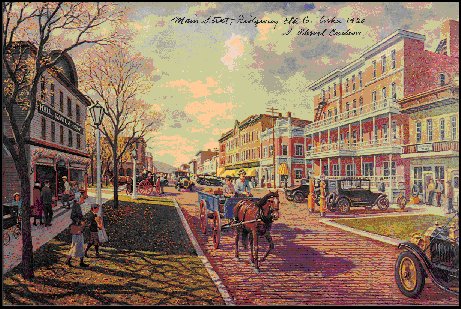
The Ridgway National Historic District with over 700 contributing properties one of the largest in Pennsylvania affords the visitor the opportunity to view the "Lily of the Valley" in its entire visual and architectural splendor. The community of Ridgway was founded in 1824 by Jacob Ridgway of Philadelphia a ship builder and industrialist that was the second richest man in Pennsylvania after Stephen Girard when in 1817 he purchased over 100,000 acres of land in north-central Pennsylvania.
Tours conducted by Bob Imhof will take you by vehicle through the historic district and adjacent properties focusing on the community's history, architecture and individuals that were significant to the development of the town as a major industrial hub. Cost=$15/person
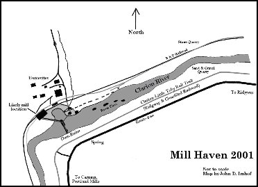
The Nationally Designated Wild and Scenic Clarion River was the life blood of the community of Ridgway from its founding in 1824 through 1864 when the first railroad system finally crossed the Allegheny Plateau. The Clarion River corridor was filled with towns and operational areas related to the highly prized forest that covered the ridges and valleys of the Clarion River corridor. The tour provided by Bob Imhof will include stops at the towns of Mill Haven, Croyland, Carmen, Portland Mills, Arroyo, Irwintown ending in Hallton where Spring Creek joins the Clarion River. Cost=$25/person
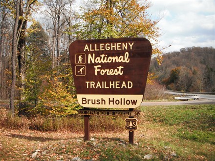
The Brush Hollow Trails offer three loops totaling 12.4 kilometers (7.7 miles) for cross-country skiing, hiking and mountain biking. The Mill Creek Trail (5.6 miles) connects the Brush Hollow Trails with the Twin Lakes Trail. This trail is best suited to hiking. The trailhead offers accessible parking and a restroom. This area is managed for recreation and wildlife habitat, mainly turkey and bear. Big Mill Creek is a popular trout fishing stream and is the water supply for the community of Ridgway. The trails on both sides of Big Mill Creek in the Brush Hollow Complex are remnants of the Rolfe and Northern Railroad that was active until 1925 providing pulpwood for the large paper mill that is still operational in the community of Johnsonburg seven miles North of Ridgway on the Clarion River. Click Here for a trail map Cost=$20/person
Recreational Area managed by Ridgway Township has been developed as a community use area and was the site of two sawmills beginning in the 1840's and a Civilian Conservation Corps Camp (ANF-10) during the Great Depression in the 1930's.Laurel Mill Hike and Ski Trail - This trailhead is located three miles west of Ridgway along Township Road 307 (locally known as the Spring Creek Road). Facilities include: hardened parking area, vault toilet, warming hut/shelter and informational signing. This parking area is plowed during winter activity season (12/20 - 4/1). The trails are marked with blue diamonds. Laurel Mill offers challenges to a wide range of skill levels. This trailhead accesses the 10.7 mile Laurel Mill Cross-Country Ski and Hiking Trail System, which consists of several interconnecting loops designed for the beginner (easiest) and intermediate (more difficult) skiers and hikers. The Elk Loop and Perseverance Loop are designated EASIEST and are suitable for beginning skiers. The Scout Loop, Hemlock Loop and One Mile Loop are designated MORE DIFFICULT and are suitable for more advanced skiers. The Sparrow Nest Loop is best suited to hiking. "You Are Here" signs are located at trail junctions and other key locations. Click Here for a trail map Cost=$15/person
Recreational Area managed by Ridgway Township has been developed as a community use area and was the site of two sawmills beginning in the 1840's and a Civilian Conservation Corps Camp (ANF-10) during the Great Depression in the 1930's.Laurel Mill Hike and Ski Trail - This trailhead is located three miles west of Ridgway along Township Road 307 (locally known as the Spring Creek Road). Facilities include: hardened parking area, vault toilet, warming hut/shelter and informational signing. This parking area is plowed during winter activity season (12/20 - 4/1). The trails are marked with blue diamonds. Laurel Mill offers challenges to a wide range of skill levels. This trailhead accesses the 10.7 mile Laurel Mill Cross-Country Ski and Hiking Trail System, which consists of several interconnecting loops designed for the beginner (easiest) and intermediate (more difficult) skiers and hikers. The Elk Loop and Perseverance Loop are designated EASIEST and are suitable for beginning skiers. The Scout Loop, Hemlock Loop and One Mile Loop are designated MORE DIFFICULT and are suitable for more advanced skiers. The Sparrow Nest Loop is best suited to hiking. "You Are Here" signs are located at trail junctions and other key locations. Click Here for a trail map Cost=$15/person
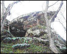
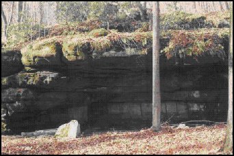
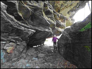
Located just off the Clarion-Little Toby Rails to Trails near the historic ghost town of Croyland and the old Civilian Conservation Corps Camp S-101 the Indian Rock Trail and formation is part of the Native American rock shelters system used over the centuries to provide shelter and rest areas for the trading and warring tribes that lived on the Allegheny Plateau and moved between the Lake Erie, Allegheny and Clarion River drainages heading to the West Branch of the Susquehanna River. Cost=$15/personn
Named for the state bird of Pennsylvania, the Ruffed Grouse, this trail system is located eight miles west of Ridgway, PA along Township Road 307 and is built on a segment of the old Bear Creek Tramroad railroad utilized during the 1920's as part of the last great timber cuts in this section of Pennsylvania. The trail includes an impoundment built by the Pennsylvania Game Commission during the 1950's for migratory flight birds and has two hiking options, a short 1-mile loop and a 2.1-mile loop through a managed wildlife area. The facilities include: hardened parking area, vault toilet and informational/interpretive signing. Click Here for a trail map
Cost=$15/person
Named for the state bird of Pennsylvania, the Ruffed Grouse, this trail system is located eight miles west of Ridgway, PA along Township Road 307 and is built on a segment of the old Bear Creek Tramroad railroad utilized during the 1920's as part of the last great timber cuts in this section of Pennsylvania. The trail includes an impoundment built by the Pennsylvania Game Commission during the 1950's for migratory flight birds and has two hiking options, a short 1-mile loop and a 2.1-mile loop through a managed wildlife area. The facilities include: hardened parking area, vault toilet and informational/interpretive signing.
Cost=$15/person
Church Run is a small tributary stream that flows in from the north to the Clarion River in Millstone Township below the town of Hallton. The significance of the stream and adjacent area is the ghost town community of Raughts that occupied both sides of the Clarion River. Raughts named for Henry Raught who came from New York State in 1839 and built his dam and a saw mill between Clyde Run and the bottom of Hoff Hill Road sometime prior to 1848. The saw mill and dam were destroyed by the Great Flood of 1861 and the property was purchased by Jerome Powell of Ridgway owner of the home you are presently staying in, The Towers Victorian Bed and Breakfast.
Mr. Powell came to Ridgway in 1850 at the age of 22 and became editor of the Elk County Advocate newspaper. The Elk County Advocate first saw the light of day on March 9, 1850. It was in size 22x28, and in appearance ranked fairly with the county papers of that day. The result was that the Advocate was published and edited by Mr. Powell, assisted for a short time in the editorial department by Henry Souther, for about five and a half years, or till September 8, 1855. The paper was then sold to prominent citizen, J. L. Brown, of Wilcox, who changed the name it is believed, to the Elk County Reporter. Jerome Powell purchased a number of lots in the southern part of Ridgway known as "out lots. These lots, known as the Powell Addition, are the area in the vicinity of Irwin Avenue, Vernon Avenue, and Powell Street. "Irishtown" was settled by many Irish people and is the area from Euclid Avenue to the Clarion River.
The church referred to by the name of the stream was a Methodist Church built just above where Church Run enters the Clarion River and a schoolhouse was built on the hillside above the church. Raughts was a thriving community and according to the 1870 census there were thirty five homes occupying the two sides of the Clarion River. The valley of Church Run is a wonderful example of Pottsville sandstone rock formations and dense laurel growth that make for a beautiful visual appearance.
Cost=$25/person